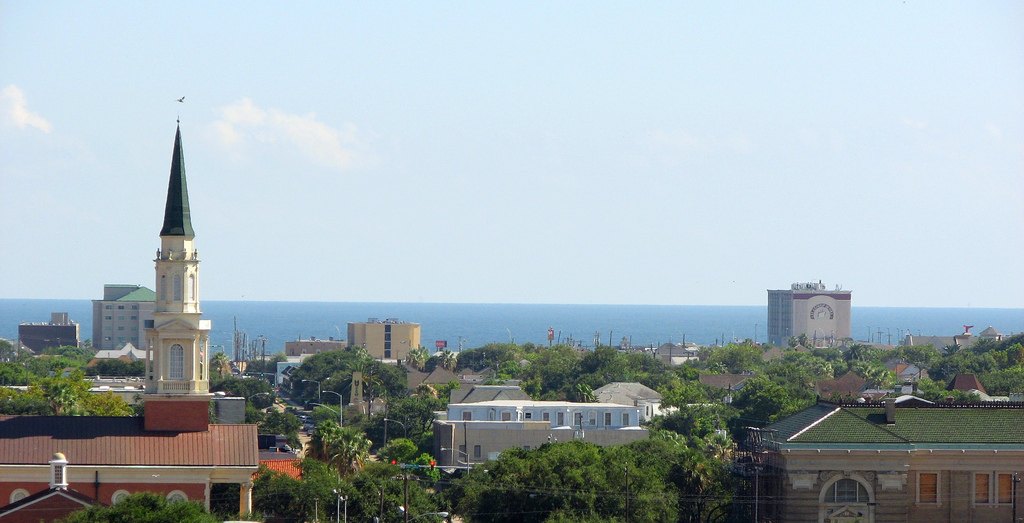
Galveston skyline looking south toward the Gulf of Mexico

Outdoors

Picnic spots near Galveston

Day-use and picnic areas near Galveston on public land, from quick drives to full-day outings.

11picnic areas
33 mito the closest
October–Maybest months

Good to know: Group picnic sites can often be reserved; fire rules change with the season, so check before bringing a grill.

Closest picks

1

Brazoria National Wildlife Refuge

33 mi southwest · Fish and Wildlife Service

Established in 1966 to provide wintering habitat for migratory waterfowl and other migratory bird species, the refuge provides more than 45,000 acres of salt marsh and freshwater sloughs, impoundments and potholes among native coastal…
3

San Bernard National Wildlife Refuge

54 mi southwest · Fish and Wildlife Service

Established in 1968, San Bernard National Wildlife Refuge is a diverse refuge that protects salt marsh and saltwater lakes, coastal prairies, freshwater lakes and marshes, intermittent streams, and riparian and bottomland forests.

Map of all 11 places

Map of 11 places loads as you scroll.

30 to 75 miles (4)

33 mi southwest · Fish and Wildlife Service

Brazoria National Wildlife Refuge

Established in 1966 to provide wintering habitat for migratory waterfowl and other migratory bird species, the refuge provides more than 45,000 acres of salt marsh and freshwater sloughs, impoundments and potholes among native coastal…

  • Biking
  • Birding
  • Boating
  • Fishing
  • Hiking
  • Hunting
  • Motor Boat
  • Non-Motorized Boating

54 mi southwest · Fish and Wildlife Service

San Bernard National Wildlife Refuge

Established in 1968, San Bernard National Wildlife Refuge is a diverse refuge that protects salt marsh and saltwater lakes, coastal prairies, freshwater lakes and marshes, intermittent streams, and riparian and bottomland forests.

  • Biking
  • Birding
  • Boating
  • Fishing
  • Hiking
  • Hunting
  • Motor Boat
  • Non-Motorized Boating

60 mi northwest · US Army Corps of Engineers

Buffalo Bayou

These normally dry reservoirs are on the west side of Houston on both sides of I-10 at TX6. They contain the largest municipal park in the Nation and provide a unique recreational experience for the metropolitan area.

  • Biking
  • Hiking
  • Horseback riding
  • Picnicking
  • Wildlife viewing

75 miles and farther (7)

87 mi north · USDA Forest Service · Campground

Double Lake Recreation Area

Double Lake Recreation Area was built in 1937 by the Civilian Conservation Corps and offers a little of everything, including camping, fishing, swimming, picnicking, hiking and simply relaxing in nature.

  • Biking
  • Boating
  • Camping
  • Fishing
  • Hiking
  • Kayaking
  • Mountain Biking
  • Picnicking

92 mi west · Fish and Wildlife Service

Attwater Prairie Chicken National Wildlife Refuge

Attwater Prairie Chicken National Wildlife Refuge was established in 1972 to provide habitat for one of the last populations of the critically endangered Attwater’s Prairie-Chicken , a ground-dwelling grouse of the coastal prairie…

  • Biking
  • Birding
  • Hiking
  • Photography
  • Picnicking
  • Ranger programs
  • Wildlife viewing

108 mi west · Bureau of Reclamation

Lake Texana

Lake Texana is formed by Palmetto Bend Dam which is feature of the Palmetto Bend Project . The lake provides over 11,000 acres of water surface and 125 miles of shoreline. Accessible from numerous roads.

  • Boating
  • Camping
  • Fishing
  • Hiking
  • Picnicking
  • Recreational Vehicles
  • Water sports
  • Wildlife viewing

110 mi north · US Army Corps of Engineers

Steinhagen Lake

Points of interest in this majestic "Big Thicket" region of Texas include four National Forests and an Indian Reservation.

  • Boating
  • Camping
  • Fishing
  • Hiking
  • Hotel/Lodge/Resort Privately Owned
  • Nature education
  • Picnicking
  • Water sports

125 mi northwest · US Army Corps of Engineers · Campground

Lake Somerville Marina & Campground

This recreation area is part of Somerville Lake

  • Boating
  • Camping
  • Hotel/Lodge/Resort Privately Owned
  • Picnicking
  • Water sports

126 mi northwest · US Army Corps of Engineers

Somerville Lake

Nearby points of interest include Bluebonnet Trails, Independence Day Trek and Salt Grass Trek.

  • Biking
  • Boating
  • Camping
  • Fishing
  • Hiking
  • Horseback riding
  • Hotel/Lodge/Resort Privately Owned
  • Picnicking

129 mi north · US Army Corps of Engineers

Sam Rayburn Reservoir

A 114,000-acre lake in the Big Thicket country of Texas, with native flora including orchids, insect-eating plants and scores of animal species.

  • Boating
  • Camping
  • Fishing
  • Hiking
  • Horseback riding
  • Hotel/Lodge/Resort Privately Owned
  • Picnicking
  • Water sports

Distances are straight-line miles from downtown Galveston. Listings come from Recreation.gov’s federal recreation database; check each official page for hours, fees, fire restrictions and closures before you go.

Get outside around Galveston

Guidebook for your next trip to Galveston, TX 🏝️ Most Texans travel to @galvestonisland to hang out video thumbnail

THINGS TO DO · YOUTUBE SHORT

Guidebook for your next trip to Galveston, TX 🏝️ Most Texans travel to @galvestonisland to hang out

A local activity Short shared by My Curly Adventures.

Watch on YouTube ↗

Around Galveston

Galveston Island Historic Pleasure Pier
Galveston Island Historic Pleasure Pier (9710926742)robert thigpen from diboll, texas · CC BY-SA 2.0
Carnival Breeze Docked in Galveston
Carnival Breeze Docked in GalvestonJason Reina · CC BY-SA 4.0
2102 Post Office Street - Galveston
2102 Post Office Street - GalvestonFarragutful · CC BY-SA 4.0

More outdoors near Galveston

Questions

Where is the closest place for picnic spots near Galveston?

Brazoria National Wildlife Refuge (Fish and Wildlife Service), about 33 miles southwest of Galveston as the crow flies. Next are Wallisville Lake (39 mi) and San Bernard National Wildlife Refuge (54 mi).

When is the best time for picnic spots near Galveston?

Based on Galveston’s average highs, October–May. Conditions at higher elevations can be much cooler.

Who manages these places?

Federal agencies including US Army Corps of Engineers, Fish and Wildlife Service, USDA Forest Service. Each listing links to its official page for hours, fees, closures and current conditions.

Galveston AI

Your Galveston local guide
Hey there!

I'm Galveston AI. Ask about neighborhood food, independent shops, local history or planning a visit.

AI recommendations may be inaccurate. Verify hours and prices. Questions are processed by Cloudflare. Privacy